In the mid 21st century, what should a world-class transport system look like for the Lake District?
Different people and organisations have different opinions about this, but the problem is that there isn’t a place to ferment ideas and explore what might be possible.
TfLD has been established to tackle this – constructively and openly. For and overview of how we plan to do this, click here.
Otherwise, here are some ideas – click on the buttons below to dive in.
It’s not a proposal. The purposes are to create curiosity and start meaningful, informed, constructive conversations across a wide range of people, organisations and voices.
TfLD is all about taking a vision-led approach to designing a transport system – setting out where we are trying to get to, then working out how to get there. This does not deny that there are a contentious ideas and issues that would need addressing – some of which are set out here – but it is not constrained by them.
These initial pages and ideas have been put together by Alistair Kirkbride – alistair@lowcarbondestinations.org.uk. They are a seed for debate and to nurture conversations with a hope that this might lead to the ideas finding homes elsewhere that can lead to meaningful change.
There are about 39,000 residents in the Lake District and about 17.7m visitors per year. The chart indicates how many people are in the Lake District on a day-by-day basis.
So what?
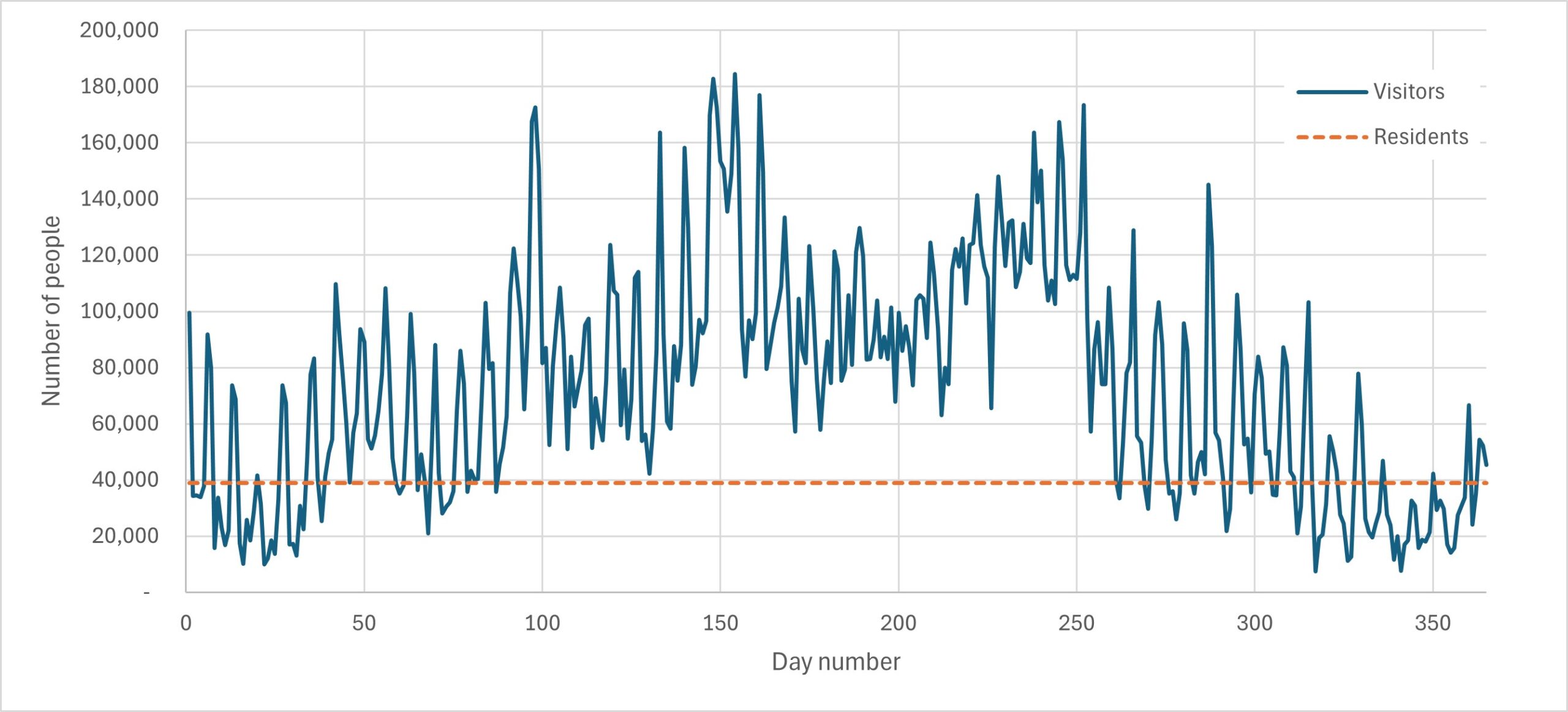 On the busiest days, there are nearly five times more visitors than residents in the park. In popular places that have low resident populations like Langdale or Ullswater valley, on peak days there can be up to 6.9 times the number of visitors to residents.
A great transport systems should deliver for all of these users. Furthermore, it needs to provide fair access regardless of whether people have access to private cars or have mobility or other issues that might impact on their ability to travel.
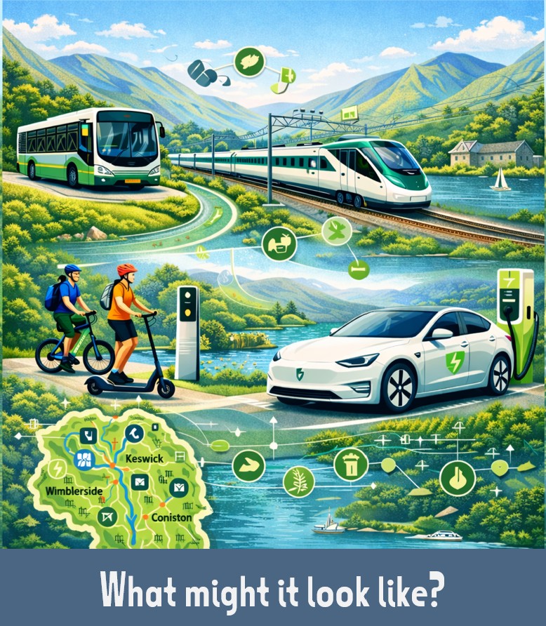
How people travel is changing. Transport for the Lake District needs to be designed not only for how people travel today, but be future-ready.
People locally want a different transport system. Recent work led by ACT Appetites to travel differently in the Lake District showed a desire for less traffic and better, integrated public transport as suggested in the graphic.
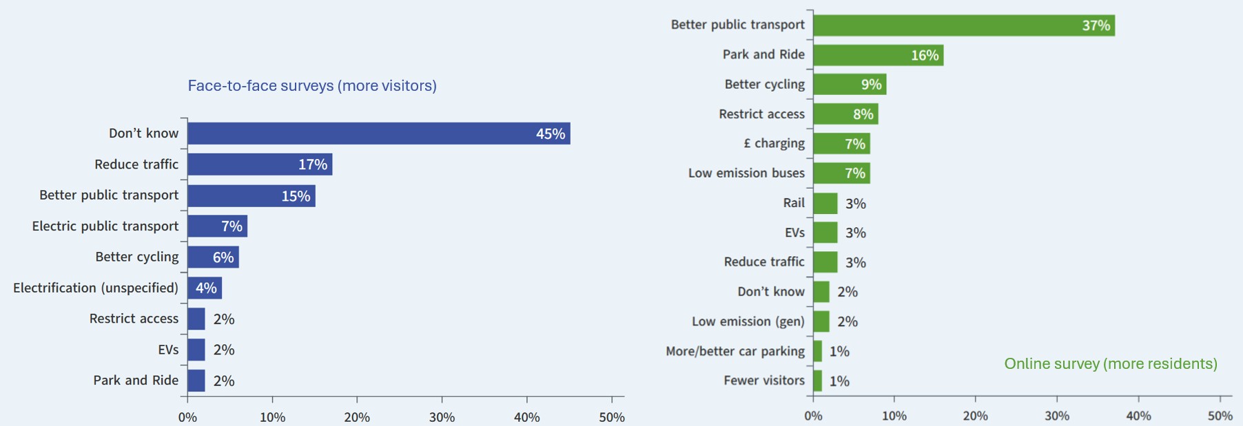
Two climate juries and a citizen’s panel covering Kendal, Furness and Copeland all led to clear recommendations for what informed members of the public want to be prioritised for transport and travel locally in the context of climate change mitigation. These are summarised in Appendix 2 of this document. Whilst expressed differently, they emphasise a public desire for better, integrated public transport and better conditions for walking and cycling.
Transport is not the end point: it allows other activities to happen such as getting to work, having a day out, going shopping etc. “Bad” transport causes problems – congestion leading to unreliable journey times, high levels of traffic causing fear/danger/noise, some people being excluded for various reasons etc.
Transport for the Lake District needs to make sure that it
Policy of the two councils (Westmorland & Furness and Cumberland) and the Lake District National Park Partnership all set out priorities that their policies are designed to deliver – such as quality of life, quality of visitor experience etc.
Different people and organisations will (always) have different priorities for a transport system and this is a common barrier to constructive debate. TfLD aims to acknowledge this up front, respect the different priorities, but not let them constrain the development of more ambitious ideas.
Work needs to be done on understanding fully the required and desirable outcomes of a transport system for the Lake District.
For instance:
 Transport accounts for more than half of the Lake District’s carbon emissions – the parts in green on the following chart. Of these, visitor travel accounts for most of this. If we are serious about carbon reduction, we need to have a transport system that leads to lower carbon emissions.
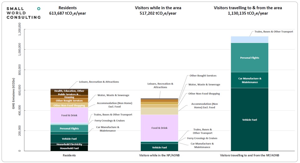
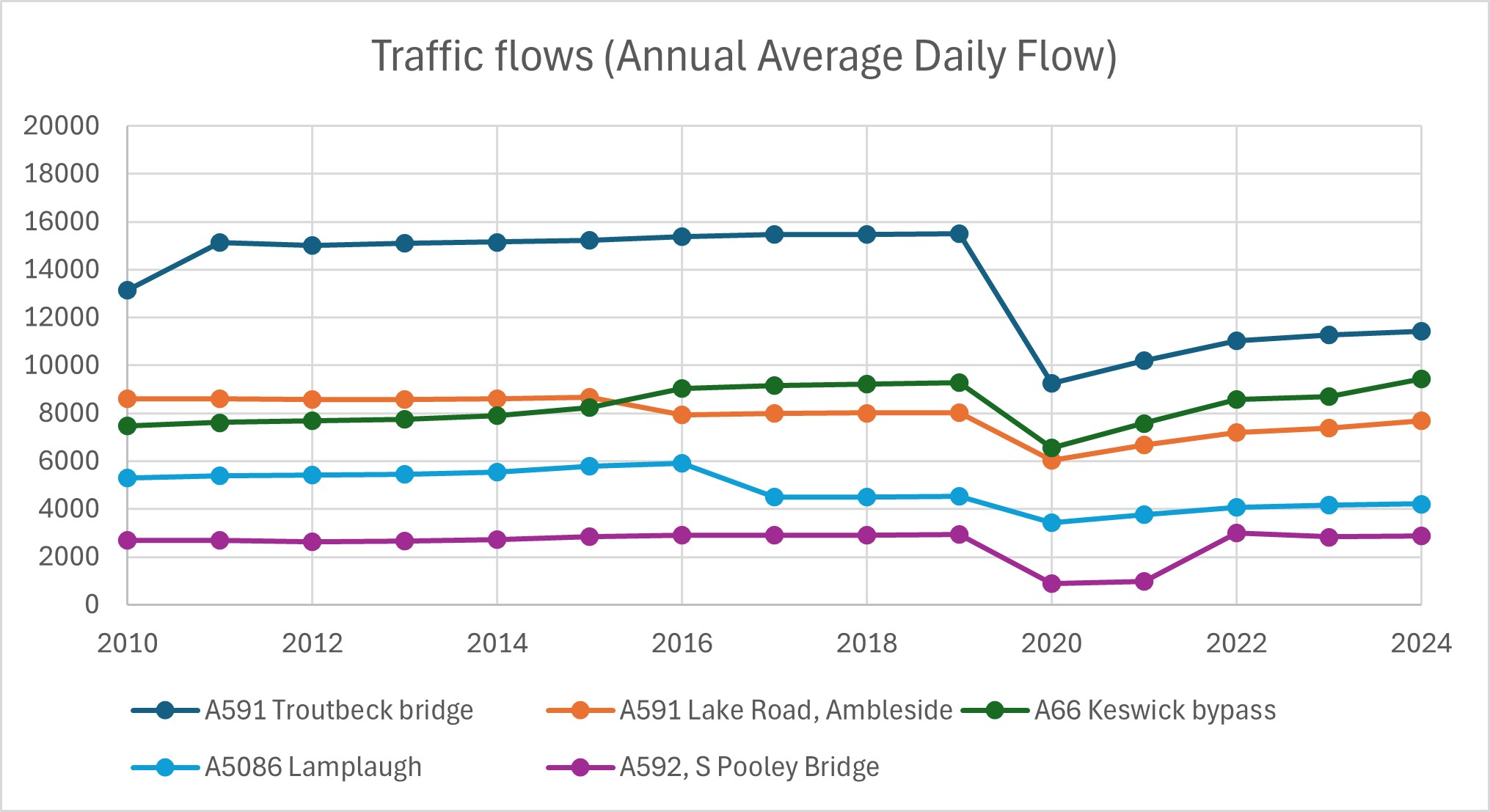 This shows that however welcome, piecemeal improvements and evolutionary change does not lead to any substantial change in how people travel – there needs to be a strategic and ambitious package of measures that locks in “good” mobility and locks out levels of traffic that blight places and lives.
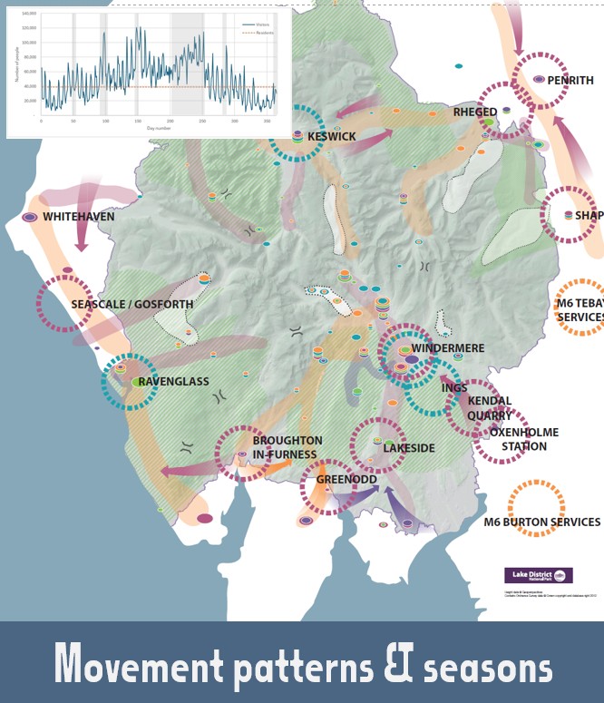
A good transport system needs to enable people to get to where they want to get to when they want to go. Designing this means understanding movement patterns and seasonality – or “busyness”
Patterns of movement are fairly stable over time but how people travel changes. Transport for the Lake District aims to set out ideas for how services and infrastructure would serve the demands of travel patterns.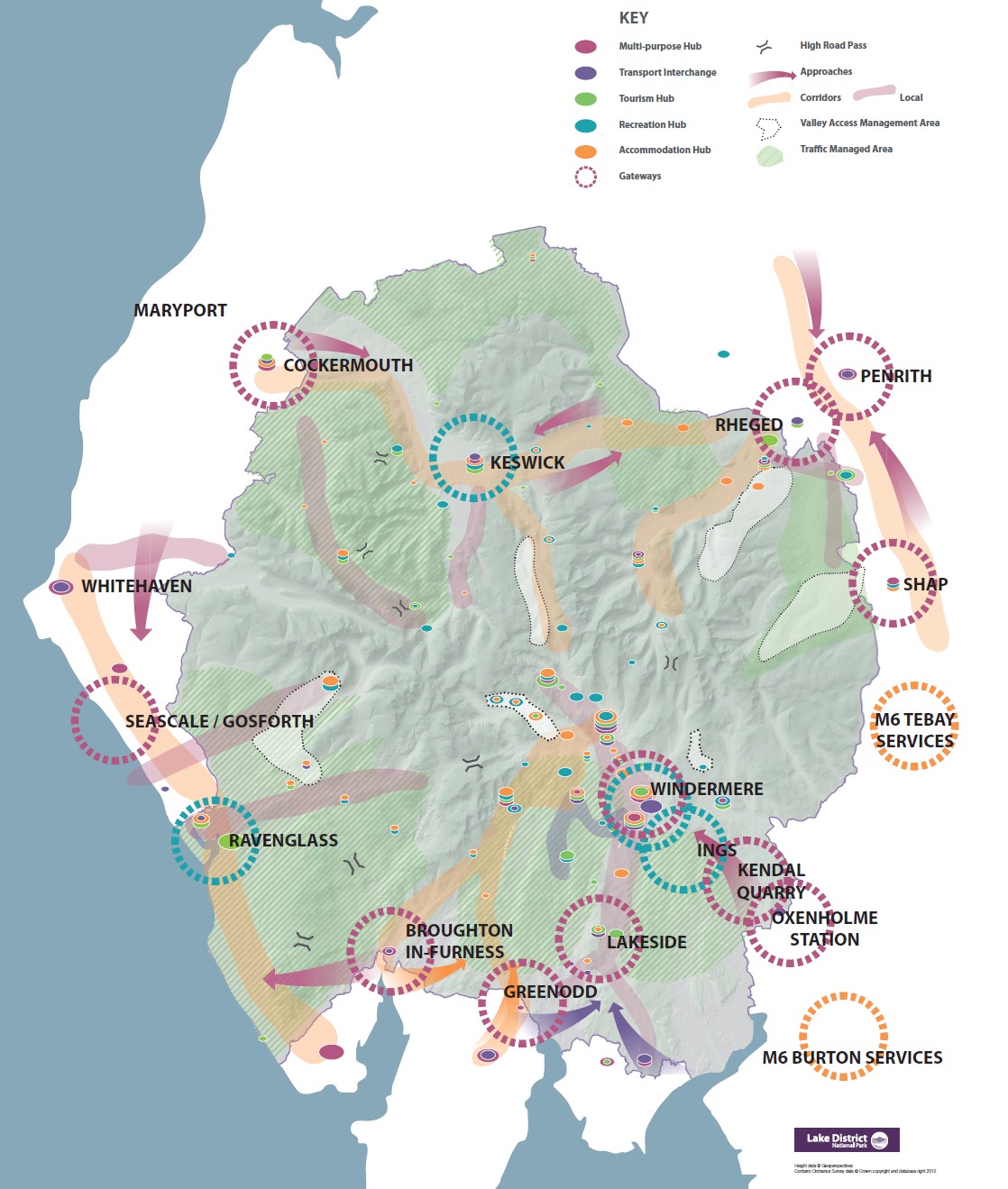
So what are the movement demands and how might we start designing a system to cater for them for the mid 21st century? It might sound like a simple question, but it’s tricky to answer. The image aims to do this in a way for visitor travel that starts to inform what transport infrastructure and services might be needed where. It looks at movement in terms of
What can be done to plant ideas about alternatives to using a car when people are planning trips to the Lake District? What other types of services are needed?
How could or should the approaches be designed so that the transition from approach journey to travel in the Lake District is better managed?
How should gateways function – and what sort of facilities should they include? Where could or should they be located? Are they a single location or a zone for different ways to transfer between the approach journey and travel in the Lake District?
What sort of transport services should serve the travel demands along the corridors? how should traffic be managed?
This was designed as a framework to help map out how all of these parts might work differently for a world-class transport system.
So how might these be designed to enable a visitor to travel from Newcastle to Buttermere for the weekend? How might a teacher get to work in Coniston from Barrow in November?
It’s well known that the Lake District is very seasonal and this is reflected in its transport system; summer has great services but also suffers from peak-season congestion.
The chart indicates overall “busyness” for the Lake District. 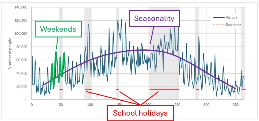 This is built on daily data from several large car parks across the Lake District scaled up to total visitor numbers. There are three main components:
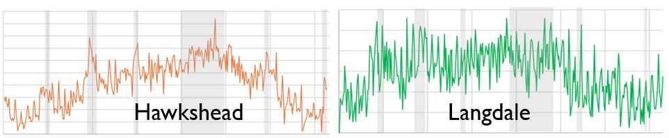
It’s been shown in recent years that different valleys have different “busyness” characteristics. The following chart shows that Hawkshead is very seasonal compared to Langdale which is dominated by weekend busyness over about 9 months of the year.
So how should “busyness” inform the design of transport? It clearly shows the need for more services for busy times, but how might the visitor revenues from services at busy times help provide off-season services for residents and businesses?
These ideas are based on a combination of sources:
The LCD button in the content below links to more detailed information and examples of best practice in the Low Carbon Destinations website.
Click on the buttons to jump to the content

This is probably the most significant difference compared to business as usual and might be an issue that causes discomfort for some at the moment because of a sense of the unknown. Really great transport systems in other rural areas with significant tourism around the world – such as many alpine destinations – feel different, but most people would say they are impressed and a bit jealous; the challenge of TfLD is to set out what a really great transport system would feel like for the Lake District. A different “social contract” is needed that mines the idea of reciprocation – about a deal being done between the person travelling and the “place” that has provided the opportunity to do so.
This borrows from the norms of US national parks – where it is just accepted that access at busy times is explicitly managed, and that this is a part of providing better experiences. The definition of peak season will need exploring on more detail, but generally involves all school holidays & public holidays, weekends from February half-term to the end of September and some summer weeks out of the school holidays, perhaps different in different locations.

This is so that the volumes of parking and traffic “fit” into the locality rather than clogging it up. This will be enabled by suitable amounts, variety, flexibility and quality of alternative transport services for visitors at these times/in these places. The experience will be better than congested roads and parking.
Access at peak times will be prioritised. This will consider the relative needs of emergency vehicles and public transport, people with mobility restrictions, people using active travel, residents & business access, pre-booked visitor parking (including at accommodation & attractions), vehicles in transit, on-spec vehicles.
Like many US national parks, the idea of peak and off-peak access arrangements will be widely communicated and understood by the public.
In the off-peak season:
This section covers seven main ideas:
Car parking will operate by zones – complemented by alternative transport and access options to deliver zone-appropriate experiences for visitors and enable essential road access to be unimpeded. The zones would be defined by “carrying capacity” – a combination of landscape sensitivity and highway capacity, including traffic contribution “upstream” at bottlenecks. There would be :
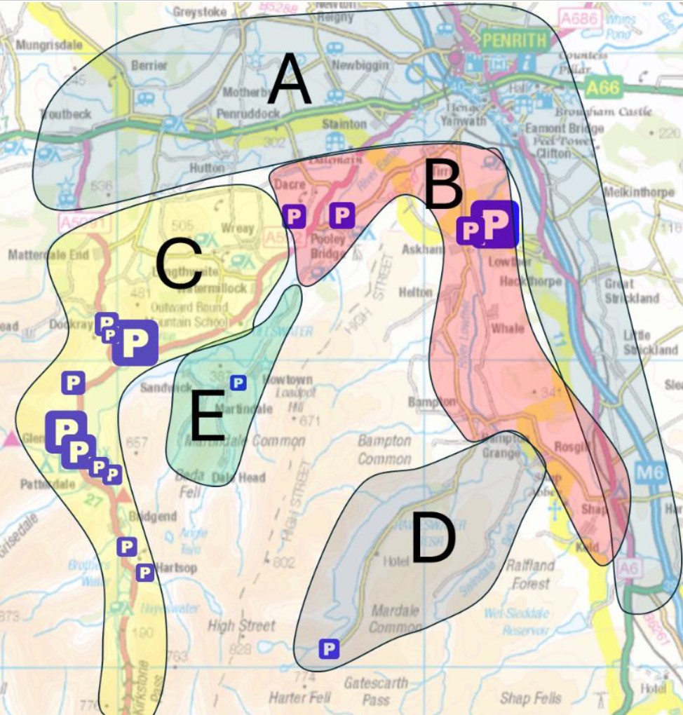 – no visitor car access. These might be quiet lanes zones where active travel is prioritised or busy and popular valley heads where non-essential traffic blights or hinders other experiences or access (Zones D & E on plan of Ullswater and Lowther valleys)
Buses & shuttles would “sweep” car parks along their routes.
Mobility hubs include anything from rail/bus interchanges with car parking, “Gateway” sites 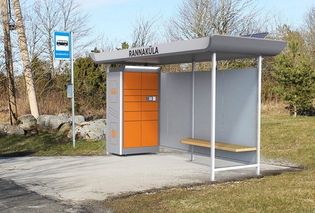 involving Park & Ride and coach / bus interchange, a jetty served by launches or a humble isolated bus stop.
Making an integrated transport system easy to use involves a well-designed cascade of hubs, where function at each point is designed for that location (how it works within the transport network), and to make sure that there is consistency and continuity of design across all hubs. An 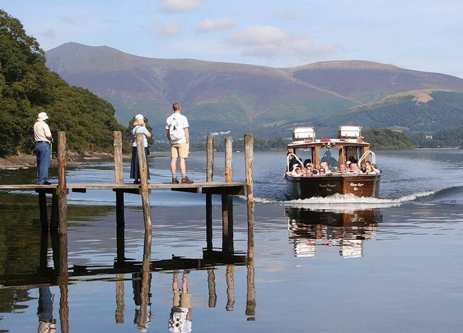 isolated bus stop might require shelter, and its functionality might benefit from WiFi signal (if mobile signal poor) and perhaps doubles as a location for parcel lockers for the local residents and a secure rideshare/hitching station.
Work has already been done on different types of hubs for the Lake District as part of the 2011-15 GoLakes Travel programme (what might be appropriate components at places where the main function is accommodation, recreation, trail heads etc), and this could be updated with respect to the more recent mobility hubs ideas.
Public transport would cater for the enhanced demand through an integrated network of service types. Services will be pinned to the Gateway – corridor – hub skeleton and the mobility hubs for efficient mobility.
Timetables will stretch from early-morning to late-night for many places (like in most Alpine valleys), reach extended beyond core corridors and frequencies enhanced so that popular corridors will effectively become turn-up-and-go.
Limited stop express buses along corridors (for point-to-point journey speed) would be complemented with stopping services on corridors and explorer/rambler services off corridors. Demand responsive services and/or taxi-bus-type services would cover lane networks where geography and nature of demand make these an appropriate option.
Suggestions of what “world class” bus networks might look like are presented for Langdale, Ullswater and the Hawkshead area on pp 14-18 in this document.
Modern transport systems enable
This means safe, continuous route from/to where people want to go, prioritising these modes where it is appropriate or necessary for safety. It also involves good wayfinding – signage, maps and accompanying information that works for the users. Complementary to infrastructure are “soft” measures – guiding, buddying, advice etc.
These might be by a combination of standard rental (day, half-day, dropped off for visitors etc), PAYG share schemes, loans, try-before-you-buy etc. Different models and a description of how they fit in different contexts are summarised on page 18 of this document.
In Werfenweng (Austria), a whole range of “micro-mobility” options are available as part of the visitor offer, marketed as a fun way of exploring locally. In the Lake District, a small fleet of Twizys (micro-EVs) were trialled as part of the GoLakes Travel programme; this video illustrates well how innovative mobility can be bedded into the distinctive character of the destination – is this transport or experience – and does it matter? 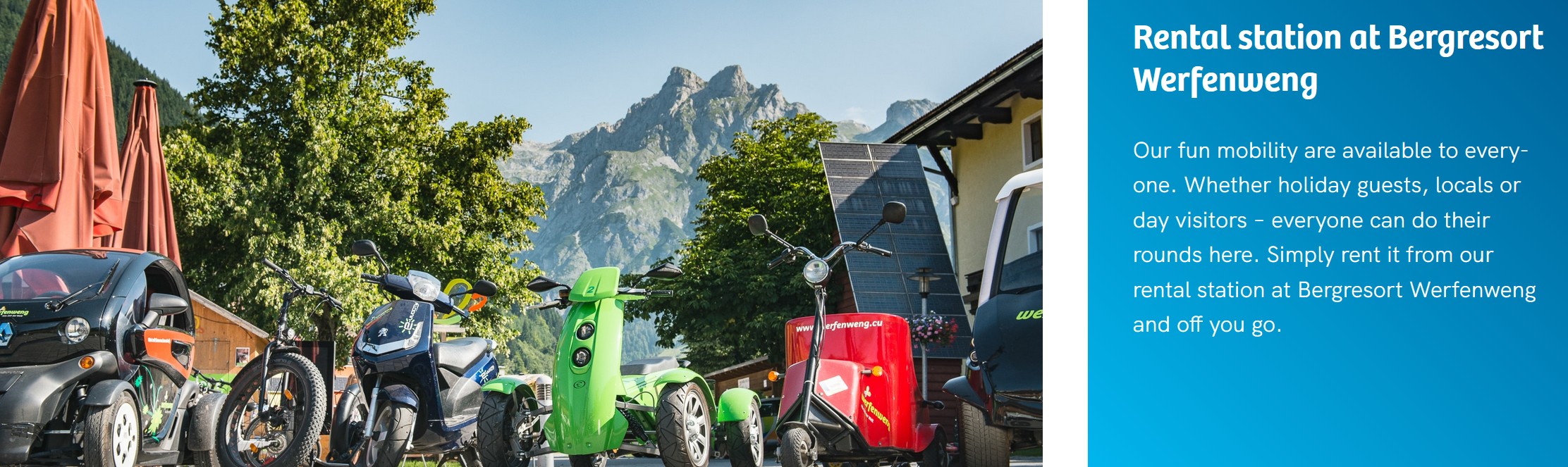
Indications of what world-class bike & micro-mobility might look like for Langdale, Ullswater and the Hawkshed area are presented in pp 19-22 of this document.
Most people have experience of travelling in places where ticketing  for transport is made really simple. This might be tapping on and off the tube & buses in London, or being presented with a “guest pass” for local travel as a staying visitor in many alpine destinations.
Such simplicity and transparency helps to demystify the use of the transport system, removes the sense of cost risk, and – in a visitor context – provides a real sense of welcome.
Many models of ticketing and guest pass exist. For the Lake District, passes would need to be designed for different user types and the nature of their demand.
many European destinations in providing an access pass for staying visitors with paid-for enhancements.
Information for how to get around will:
Transport will be marketed as the ability to access places easily. It will become a part of destination marketing and the profile of the Lake District in a similar way how the quality of the Swiss rail system is associated with the destination.
The economic and governance models that enable and maintain the types of systems implied here will probably need to be different to those that exist today. There is nothing in current legislation to prevent anything described here if there is a shared ambition for it to happen.
Three key changes to legislation and governance are emerging that are relevant:
A common aspect of rural destinations overseas that have world-class transport systems is valley-scale governance. This is often nested into sub-regional & regional governance and economic models for transport, but significant decisions and finance exist at the valley scale.
The main roles of the public sector are
The systems implied here would require a deliberate transition from the way that transport currently works.
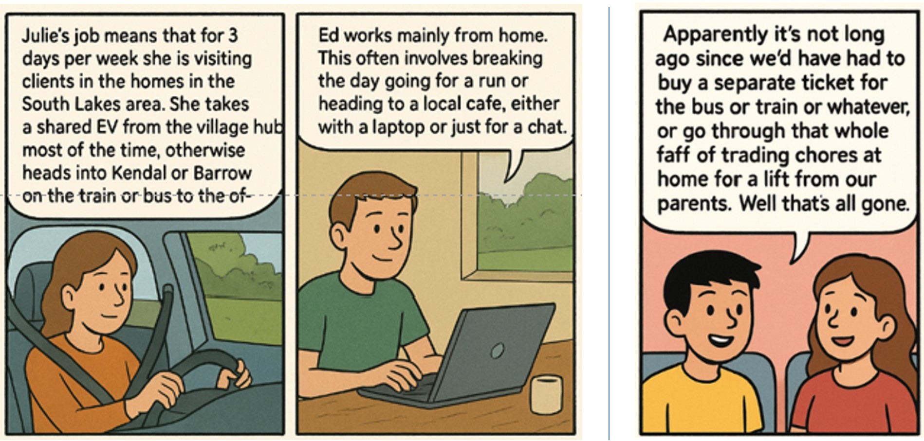
Many people use transport systems for different reasons in different ways.
Work has already been done on What might carbon-reduced transport look and feel like in Cumbrian communities? .
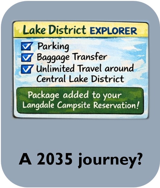
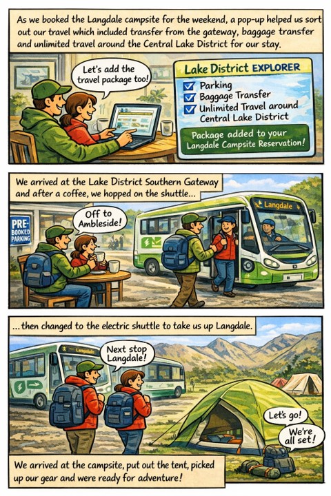
And here is a flavour of a couple visiting for the weekend…
Let’s not pretend for a second that what is implied here will be easy.
The a key purpose of vision-led planning is to work out together what a better future might look like. This means that conversations can turn to what joint efforts would need to happen to get there – accepting that not everyone agrees on all of the details. It also requires backcasting to be used – which explicitly identifies barriers and problems, but it a context wher the aim is to find solutions, not to prevent progress.
All too often, progress is thwarted by barriers – preventing even starting conversations. Here are a few – just to start getting them out there. The challenge is to consider the opportunities that would flow from the ideas floated here, then ask whether these are worth preventing progress.